Seasonal Timeline
Mazama pocket gophers are active every month of the year and around the clock. They do not hibernate. What changes seasonally is how much dirt appears on the surface, and that tracks soil moisture: mound building in western Washington rises noticeably after the first significant fall rains and drops off in summer when the ground bakes hard.
Mazama pocket gophers are active every month of the year and around the clock. They do not hibernate. What changes seasonally is how much…
There is no closed season on this animal, because there is no open one. The gopher is awake and underground twelve months a year, with activity spread across the full 24-hour day and a measured peak in late afternoon to early evening. Digging stops only when soil is frozen or fully saturated. Under normal field conditions a gopher tunnels at about 1.5 centimeters per minute, and Oregon animals were measured tunneling 4.8 times faster in soft, moist soil than in hard-baked ground.
The surface calendar and the underground calendar are not the same thing, and that trips people up. Mound building in western Washington is highly seasonal and picks up after the first real fall rains. A property that looked gopher-free all August can show a scatter of fresh mounds in October without a single new animal arriving. The reverse error is more common and more expensive: concluding in July that the gophers left. They did not. They are simply not producing surface soil, because short foraging tunnels dug in dry weather get backfilled into unused chambers instead of pushed up top.
One litter a year, and that single number is the whole demographic story. Federal materials note that unlike most small rodents, and unlike other kinds of pocket gopher, Mazama pocket gophers produce only one litter a year. Sexual maturity comes at about a year old, which is late for a rodent. Botta's pocket gopher on irrigated ground can produce up to three litters a year. A population that breeds once, matures slowly, and lives on scattered prairie remnants cannot absorb losses the way a yard gopher in California can, which is a large part of why one is listed and the other is not.
Where They're Found
This is a Pacific Northwest animal, and the honest version of the map is drawn in counties rather than states.
The species as a whole lives in three states and nowhere else. Thomomys mazama is found only in western Washington, western Oregon, and northern California. The Olympic Mountains of Washington are the northern limit of the entire species range.
Washington is where the legal protection is, and it is west of the Cascades only. Washington's own wildlife agency puts the species in Thurston, Pierce, Mason, and Clallam counties. The four federally listed subspecies are narrower still: the Olympia pocket gopher (T. m. pugetensis), Tenino pocket gopher (T. m. tumuli), and Yelm pocket gopher (T. m. yelmensis) are endemic to Thurston County, and the Roy Prairie pocket gopher (T. m. glacialis) is endemic to Pierce County. Critical habitat, designated the same day as the listing, totals about 1,607 acres, all of it in Thurston County: 676 acres for the Olympia subspecies at the Olympia Airport unit, 399 acres for the Tenino subspecies on Rocky Prairie, and 532 acres for the Yelm subspecies across the Tenalquot Prairie and Rock Prairie subunits. The Roy Prairie subspecies ended up with no final critical habitat at all, because every proposed acre of it, 4,840 in total, sat on Department of Defense land at Joint Base Lewis-McChord and was exempted.
Oregon and northern California hold different subspecies, and none of them are federally listed. The Washington restrictions do not apply in those states. Oregon's wildlife agency runs the animal as the western pocket gopher and maps it from the Columbia River south to the California border in the Coast Range and along the coast, plus the Cascade Range with eastward extensions to Mosier, Paulina Lake, and Merrill in Klamath County. The species is more widespread in Oregon than in Washington. California's own life history account calls it a common, yearlong resident of meadow and grassland habitats in the Klamath and western Cascade ranges. Anyone outside Washington should stop and check with their own state wildlife agency, because the answer there is different.
On the ground, look at the soil, not the map. This animal needs loamy sand or sandy loam. Federal materials name both failure modes precisely: clay and highly silty soils are too wet, too hard to dig, and not permeable enough, while extremely sandy soils will not hold a tunnel's shape. Very rocky ground is out, and so is grassland taken over by dense Scotch broom. Occupied sites in south Puget Sound include conserved prairies, pastures, grassy airport margins, Christmas tree farms, and occasionally clearcuts. Federal survey work scored Thurston County soils by how often gophers actually turned up in them: Nisqually loamy fine sand on 0 to 3 percent slopes came out highest, followed by the Spanaway-Nisqually complex on 2 to 10 percent slopes, Nisqually loamy fine sand on 3 to 15 percent slopes, and Cagey loamy sand. Thurston County alone holds 149,935 acres of the relevant soils, and the county's permitting maps carry them forward as More Preferred and Less Preferred gopher soils. Soil texture also sets local density: about 9 gophers per acre was measured on 22 acres of loamy sand at the Olympia Airport, against about 2 per acre on roughly 70 acres of gravelly soil at Weir Prairie.
How much of that ground is left, with both agency figures rather than one. Washington's own recovery plan states that more than 90 percent of the historic prairie and savanna has been converted to agriculture or lost to urban use, and names urban development as the single largest cause at 33 percent. Federal materials put it slightly higher, estimating that 95 percent of the prairie and grassland habitat this gopher depends on has been converted or developed. The two figures come from two agencies, and both are worth knowing rather than only the more dramatic one. What is left is fragmented, and the remaining pieces are separated by distances a gopher either cannot cross or will not.
Two absences confirmed rather than skipped. No published account places any pocket gopher in Alaska or Hawaii. The family is entirely continental North American, and every range description found for this species stops at western Washington, western Oregon, and northern California.
Related Pests
Life Cycle
One litter a year is what sets this animal apart from other pocket gophers. Federal materials state it directly: unlike most small rodents, and unlike other kinds of pocket gopher, Mazama pocket gophers produce a single litter of about five pups per year. Sexual maturity waits until the breeding season after birth, at close to a year old, which is late for a rodent. Botta's pocket gopher on irrigated ground can run three litters a year. Slow reproduction on shrinking, disconnected prairie is the mechanism behind the listing, not a detail beside it.
A note on two numbers where the sources genuinely disagree. Gestation is given as 18 or 19 days in federal materials, while an older Washington account suggested about 28 days; the state's own recovery plan judges the shorter figure more likely, so 18 to 19 days is the better number rather than splitting the difference. Lifespan is reported as an average of 1 to 2 years, and a study aging 127 animals by mandible zonation lines found none older than 3, yet Washington biologists have live-trapped animals confirmed at 5 years or more. Both ends are worth knowing rather than a middle nobody measured.
Population math worth knowing before anyone panics at a mound count. Indicators of gopher numbers rise to three or four times the spring adult population once young-of-the-year disperse in late summer, then fall back. A yard that looks overrun in September is showing an annual pulse, not an invasion, and the animals producing it are solitary residents of small, tightly spaced burrow systems rather than a colony.

Pup
Juvenile
Adult
Mounds and Sign
Identification
Start with where you are standing
Geography does most of the identification work here. The Mazama pocket gopher lives only in western Washington, western Oregon, and northern California, and in Washington only west of the Cascades in Thurston, Pierce, Mason, and Clallam counties. The four federally protected subspecies are narrower still, endemic to Thurston County and Pierce County. If you are in a south Puget Sound county on open, well-drained, grassy ground, the animal under your yard is presumed to be this one until a qualified professional says otherwise, and that presumption is the safe way to be wrong.
Size and build
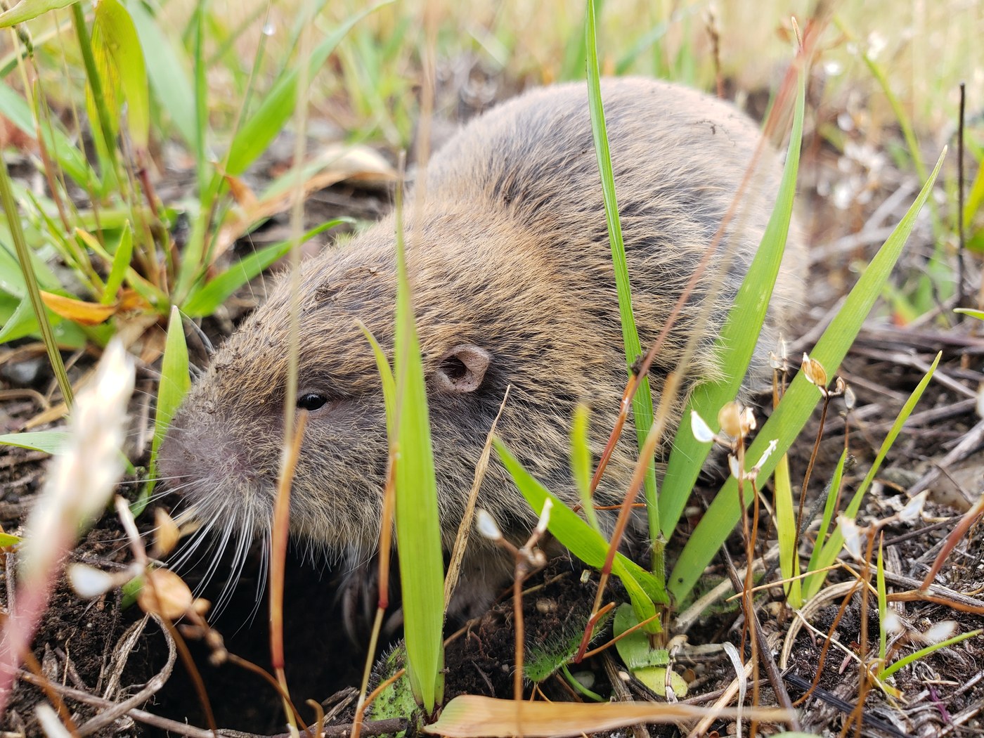
A body of about 5.5 inches plus a tail of about 2.5 inches, with published nose-to-tail figures running 7 to 10 inches, at 90 to 100 grams. Short-necked and stocky with narrow hips and short legs, small ears and small eyes, prominent chisel-like incisors that are rootless and grow continuously, and front feet with strong claws whose digits and palms are fringed in stiff bristles. The tail is short and nearly naked, and the animal can run backwards through a tunnel almost as fast as it runs forward. Males average 10 to 20 percent heavier and 5 percent longer than females.
The namesake cheek pouches
The cheek pouches are the family's namesake and settle the family instantly. External, fur-lined pouches open on the sides of the mouth and can be turned inside out like pants pockets. They are carrying bags for food, not part of the mouth. That trait is shared only with the pocket mice and kangaroo rats, so a fur-lined external pouch rules out every mole, vole, and rat you might otherwise be looking at.
Northern pocket gopher, not in the field
Northern pocket gopher is the look-alike among gophers, and the reliable character is not a field character. The northern pocket gopher (Thomomys talpoides) is similar in size and is the species commonly found in eastern Washington. Two things point at Mazama: the pelage is red brown rather than the yellow brown and gray brown of the northern gopher, and the dark patch of fur behind each ear is noticeably more obvious. The genuinely dependable discriminator, described as reliable even in juveniles, is the length of the baculum, which runs 20 to 31 millimeters in adult Mazama pocket gophers against 10 to 17 millimeters in the northern. That is a measurement taken on a dead animal in a museum, which is a good reason for a homeowner not to be trying to key a protected rodent to species in the first place.
Moles, and it happens at the mound
The confusion that actually causes legal trouble is with moles, and it happens at the mound. In western Washington the animal a gopher gets mistaken for is a mole, most often the coast mole (Scapanus orarius). Moles are insectivores, not rodents: no gnawing incisors, a pointed snout, and front claws oriented out to the side rather than forward. Neither animal is often seen, so the mound is what you read. A homeowner who calls a listed gopher's mound a molehill and sets a mole trap has a legal problem, not just a wrong identification.
Three mound tells
Three separate mound tells, and the third is the one nobody publishes. Shape and origin: a mole pushes soil straight up a vertical shaft, making a circular, dome-shaped or volcano-like mound, while a gopher pushes soil out sideways from an inclined lateral tunnel, making a fan-shaped mound or an irregular clump. Plug: a gopher hole carries an earthen plug, and a mole mound does not. Particle size: the broad hands of a mole dislodge large chunks of earth that get shoved up into the mound, while the scratch-digging of gopher claws produces fine-particled soil that gets ejected out of the burrow opening. Coarse chunks in a volcano means mole. Fine soil in a plugged fan means gopher.
Agencies word the mound differently
Agencies describe the mound in slightly different words, and it is not a contradiction. Washington's wildlife agency describes the gopher mound as fan-shaped or an irregular clump. California integrated pest management sources describe the same mound as crescent or horseshoe shaped. Both are describing an asymmetric pile with the plugged hole off to one side, seen from different angles. The Washington wording is the one to go by, because Washington's agency is the authority for this species.
A winter sign that belongs to gophers alone
Where snow accumulates, pocket gophers stay active beneath it and pack their discarded soil into tunnels in the snow. When the snow melts, that soil is left lying on the ground surface as long, sinuous ropes of earth. Nothing else in a Pacific Northwest yard leaves that mark.
The subspecies counts do not agree
Published counts for this gopher conflict, and the difference is worth knowing. The standard revision placed 15 subspecies in Thomomys mazama, 8 of them in Washington and 7 in Oregon and California. Of the 8 Washington forms, 4 are federally Threatened and 2, the Tacoma and Cathlamet pocket gophers, are believed extinct. Washington's own materials variously describe 6, 7, or 8 Washington subspecies depending on whether extinct forms are counted, and one regional partnership summary says 9 rangewide. There is also an apparent transposition in the 2014 federal listing rule, which pairs the Shelton pocket gopher with T. m. louiei and the Cathlamet with T. m. couchi, the reverse of the state's own table and of the geography the names come from. The state table is the one to trust: couchi is Shelton in Mason County, louiei is Cathlamet in Wahkiakum County.
Signs of Infestation
Every sign here means a phone call
The correct response to every sign below is a phone call rather than a control decision. There is no infestation to detect. This animal does not enter buildings, does not nest in structures, and no source documents any foundation, hardscape, or structural damage from it. What follows is what a person in south Puget Sound might actually notice on the ground.
Fan-shaped mounds, hole off to a side
Fresh soil mounds, fan-shaped or in irregular clumps, made of fine soil, with a plugged hole off to one side. This is the primary sign and usually the only one. Mound activity rises noticeably after the first significant fall rains, which means a scatter of new mounds in October on ground that looked clean in August is normal seasonal behavior rather than new arrivals.
Plants wilting or disappearing
Plants wilting, collapsing, or disappearing outright. Pocket gophers eat roots, bulbs, and stems from below and can pull an entire small plant down into a tunnel. A plant that vanishes with no damage visible above ground is the signature.
Bark gnawed higher than makes sense
Bark gnawed on young trees, sometimes higher up the trunk than makes sense. In snow country the animal works under the snowpack and can girdle above the normal ground line. On conifer plantings and orchard rows this is the damage that turns a nuisance into a loss.
Soil ropes after snowmelt
Sinuous ropes of soil lying on the surface after snowmelt. Soil packed into snow tunnels over the winter, left behind when the snow goes.
Nothing audible and nothing you can smell
No published account documents an audible or olfactory sign for this species. In the other direction, gophers retreat to deeper nests when something approaches above ground, which points to high sensitivity to low-frequency sound and ground vibration. The animal hears you long before you hear it.
What you should not expect, stated plainly
No droppings in a structure, no chewing inside walls, no scratching in a ceiling or attic, no odor, no settling foundation. Pocket gophers are the only truly subterranean rodents in North America and they stay in the soil. If something is getting into your house, it is not this.
Prevention and When to Call a Pro
There is no removal guide here
There is no removal guide for this animal, and there could not be one. Four subspecies are federally Threatened and every Washington subspecies is state Threatened. There is nothing to exclude, because this animal never enters a building. What follows is the do-not list, the one narrow thing that helps, and who to call.
Four Washington counties, no control
Do not trap, poison, gas, flood, or dig out a pocket gopher in Thurston, Pierce, Mason, or Clallam County, Washington. Washington's own wildlife agency states it in one sentence: because only remnant populations exist, people are not permitted to use lethal control in these areas. Unlawful taking of a state Threatened species is a misdemeanor under state law. Federal materials separately name pest control methods like trapping and poisoning among the documented threats to the four listed subspecies, so this is not a paperwork technicality, it is one of the reasons for the listing.
The residential exemption is misread
Do not read the residential exemption in the federal rule as permission to control gophers. This is the single most misunderstood point about this animal. When the four subspecies were listed in 2014, a special rule was issued at the same time exempting certain activities from the federal take prohibition: general activities on agricultural and ranching lands, regular maintenance at civilian airports, control of noxious weeds and invasive plants, maintenance of roadside rights-of-way, and limited activities on private landowner parcels, described by the state as ongoing single-family residential noncommercial activity. That exemption covers incidental take arising from ordinary continuing activity. It is not authorization for deliberate lethal control, and anything outside the listed activities falls back to the general federal prohibitions and requires a permit.
State law still reaches you
And even where the federal rule would not reach you, state law still does. These are two independent layers. Mason County and Clallam County hold Mazama pocket gopher subspecies that carry no federal listing at all, and those animals are still state Threatened and still off limits to trapping or poisoning without a special permit. Do not use federal listing status as your test for whether you may act. In Washington, the state answer is the binding one.
Get the permit before you dig
Do not start ground-disturbing work on mapped gopher soils before you have the permit in hand. In Thurston County, projects on parcels with mapped habitat conservation soils go through the county's permit process, the published best management practices are mandatory rather than advisory because the county's own federal permit requires them, and no clearing, grading, or other ground disturbance may occur before written approval. Think about the whole project envelope, not just the house: driveway, septic, drain field, well, material staging, and yard all count.
Do not hire a removal company
Do not hire a pest control or wildlife removal company for this animal. In the listed counties there is no lawful removal service to perform, and no pest management professional holds authority over a listed species. A firm that offers to take care of gophers on a Thurston County property is offering something it cannot legally deliver.
The county maps can be challenged
Do not assume the county maps are the last word, because there is a documented way to challenge them. A permit applicant who believes the mapped gopher soils are wrong on their parcel can commission a site-specific soils survey by a county-approved qualified natural resource professional, following the method set out in the county's conservation plan appendix. A documented absence of the mapped soils on all or part of a property can remove that ground from coverage and from the associated mitigation. This is the productive version of arguing with the map.
Fight Scotch broom instead
The one genuinely useful thing a landowner can do for this species is fight Scotch broom. It is the most visible invasive plant on these prairies and it can cover open ground fast. Gophers rarely occur where grassland has been taken over by dense broom, and occupancy is measurably higher where broom density is low and vegetation is shorter. Control of noxious weeds and invasive plants is explicitly on the federal exempt-activity list, so this is both permitted and helpful. It is the rare case where the conservation action and the property-maintenance action are the same action.
Who to Call, in Order
For any project or permit question in Thurston County, the county's community planning department, which administers the habitat conservation plan permitting and the mapped soils. For the federal route, including preparing your own conservation plan, the U.S. Fish and Wildlife Service Washington Fish and Wildlife Office, the Ecological Services office in Lacey that handles this species. Get its current phone number from the agency's own office page rather than from an older rulemaking document, because those contact details change. For anything else in Washington, and before any control action anywhere in the state, your local Washington Department of Fish and Wildlife office. In Mason County, where the animal is state listed but not federally listed, a project needs a habitat management plan submitted to the county, which then consults the state agency.
Outside Washington, none of this
If you are outside Washington, these restrictions do not apply to you, and you should not act as if they do. The Mazama pocket gopher subspecies in western Oregon and northern California carry no federal listing, and pocket gophers there are handled under ordinary state wildlife rules. Confirm the current rule with your own state wildlife agency rather than assuming Washington's treatment travels.
Frequently Asked Questions
Is the Mazama pocket gopher endangered?
Threatened, not endangered, and only some of it. Four subspecies were listed as Threatened under the Endangered Species Act effective May 9, 2014: the Olympia, Roy Prairie, Tenino, and Yelm pocket gophers, which live only in Thurston and Pierce counties, Washington. The other Washington subspecies carry no federal listing. Separately and independently, every Mazama pocket gopher subspecies in Washington has been listed as Threatened by the state since 2006, which is why the animal is off limits in Mason and Clallam counties too.
Can I trap a pocket gopher in my yard in Olympia or Yelm?
No. Washington's wildlife agency states that because only remnant populations exist, people are not permitted to use lethal control in Thurston, Pierce, Mason, and Clallam counties, and unlawful taking of a state Threatened species is a misdemeanor under state law. Contact your local Washington Department of Fish and Wildlife office before any control action. Elsewhere in Washington, pocket gophers are unclassified, live traps need no permit, and any trap other than a live trap needs a special trapping permit.
The federal rule exempts single-family residential activity. Doesn't that mean I can deal with gophers on my own property?
No, and this is the most common misreading of it. The 2014 special rule exempts incidental take arising from a defined list of ordinary continuing activities, including some single-family residential activity, from the federal take prohibition. Incidental means take that happens as a side effect of the activity, not take you set out to cause. It is not authorization for deliberate lethal control. On top of that, Washington's own protected-wildlife law bars trapping and poisoning a state Threatened species without a special permit, and that applies whether or not the federal exemption covers what you were doing.
How do I tell a gopher mound from a molehill?
Three tells, and the third is the one most sources skip. Shape: a mole pushes soil straight up a vertical shaft into a circular, volcano-shaped mound, while a gopher pushes soil out sideways from an inclined tunnel into a fan shape or an irregular clump. Plug: a gopher hole has an earthen plug set off to one side of the mound, and a mole mound has none. Particle size: a mole's broad hands dislodge large chunks of earth, while a gopher's scratch-digging claws eject fine-particled soil. In south Puget Sound this distinction matters legally, not just cosmetically, because setting a mole trap on a listed gopher is a violation.
Is this the same as the gopher tearing up yards in California?
No, and the difference matters more than anything else about this animal. The animal most people mean is Botta's pocket gopher, a different species that California classifies as a nongame mammal, controllable at any time by any legal method with no permit and no season. The Mazama pocket gopher is a Pacific Northwest species whose Washington subspecies are all state Threatened and four of which are federally Threatened. Same family, same fan-shaped mounds, same chewed roots, opposite legal answer. Getting the two confused in the wrong county is how people end up in trouble.
Do I need a gopher inspection before I build in Thurston County?
Not the old kind. The county no longer runs seasonal gopher inspection windows. Projects on parcels with mapped habitat conservation soils now go through the county's year-round permit process, which covers both the federal and local requirements for most applicants, with mandatory best management practices, a county site visit, and mitigation calculated from the final site plan. If you would rather deal with the federal agency directly and prepare your own conservation plan, that route stays open, and you will still need county permits afterward.
Will a Mazama pocket gopher get into my house or under my foundation?
No. Pocket gophers are the only truly subterranean rodents in North America, they maintain sealed burrow systems plugged with soil, and no source documents this species entering a structure or damaging a foundation. The damage they do cause is to roots, bulbs, stems, young tree bark, and the look of a lawn or pasture. If something is getting into your house, it is a different animal.
Do pocket gophers carry diseases?
No published source documents a human-disease reservoir role for this species. Washington's recovery plan states that Mazama pocket gophers are not believed to be reservoirs for any human diseases, and while two flea species and several chewing lice have been identified from them, parasites have not been reported to cause mortality in the species. That statement rests on a single source rather than on two independent ones, so treat it as documented rather than settled, and keep normal distance from any wild animal regardless. In the listed counties you are not permitted to handle one in any case.
Sources
- Endangered and Threatened Wildlife and Plants; Threatened Species Status for the Olympia Pocket Gopher, Roy Prairie Pocket Gopher, Tenino Pocket Gopher, and Yelm Pocket Gopher, With Special Rule; Final Rule, 79 FR 19760, April 9, 2014: the four listed subspecies and their binomials, the Thurston and Pierce County ranges, the effective date of May 9, 2014, the full 4(d) special rule exempt-activity list, and the subspecies removed from the candidate list U.S. Fish and Wildlife Service, Federal Register
- Endangered and Threatened Wildlife and Plants; Designation of Critical Habitat for Mazama Pocket Gophers; Final Rule, 79 FR 19712, April 9, 2014: the 1,607 total acres in Thurston County broken out by subspecies and unit, the exemption of all 4,840 proposed Roy Prairie acres on Joint Base Lewis-McChord, and the statement that all eight Washington subspecies are state listed as threatened U.S. Fish and Wildlife Service, Federal Register
- Mazama Pocket Gopher Recovery Plan and Periodic Status Review (2020): state Threatened listing since 2006 and the misdemeanor penalty, the full subspecies status table by county, taxonomy and the 15-subspecies revision, body and tail measurements, the northern pocket gopher and mole identification tells including mound shape, plug, and particle size, burrow and nest chamber dimensions, home range figures, reproduction and growth, longevity, dispersal distances at Joint Base Lewis-McChord, soil preference rankings, density figures, Scotch broom effects, predators, and the disease statement Washington Department of Fish and Wildlife
- Mazama pocket gopher species page and Living with Wildlife: Pocket Gophers: the Washington county range, size and coloration, the dark ear patch tell, one litter a year with an average of five young, the statement that people are not permitted to use lethal control in the listed counties, and the trapping permit rules elsewhere in the state Washington Department of Fish and Wildlife
- Olympia Pocket Gopher (Thomomys mazama pugetensis) species profile: nose-to-tail size, the 18 to 19 day gestation and single annual litter, altricial pups and forced dispersal by the mother, the 1 to 2 year average lifespan, the clay, silt, and extremely sandy soil exclusions, the 10,000 to 12,000 year old glacial soils, the estimated 95 percent prairie habitat conversion, and trapping and poisoning named among documented threats U.S. Fish and Wildlife Service
- Recovery Plan for Four Subspecies of Mazama Pocket Gopher (2022): the recovery strategy, reserve and population criteria of at least 1,000 individuals per local population, the note that the species includes numerous subspecies in Washington, Oregon, and California while the plan addresses only the four listed ones, and the estimated recovery timeline and cost U.S. Fish and Wildlife Service
- Gopher Inspections and Habitat Conservation Plan pages: the end of seasonal gopher inspection windows, the year-round county permitting process covering both federal and local requirements, the option to work directly with the federal agency instead, and the Certification of Inclusion Thurston County Community Planning and Economic Development
- Critical Areas and Regulated Land Codes: mapped Mazama pocket gopher habitat and More Preferred and Less Preferred gopher soils, the requirement that best management practices are not optional, the whole-project-envelope rule covering house, driveway, septic, drain field, well, and staging, and the site-specific soils survey path for challenging the mapping Thurston County
- Western pocket gopher in Oregon: the Oregon range from the Columbia River to the California border in the Coast Range and along the coast, plus the Cascade Range with eastward extensions to Mosier, Paulina Lake, and Merrill in Klamath County, and the regional pelage variation Oregon Department of Fish and Wildlife
- Life history account for Mazama Pocket Gopher, California Wildlife Habitat Relationships System, M084: the species as a common yearlong resident of meadow and grassland habitats in the Klamath and western Cascade ranges, the friable soil requirement, and the solitary territorial burrow system California Department of Fish and Wildlife
- South Puget Sound Mazama Pocket Gopher 2015-2016 Action Plan Summary, and the South Puget Sound program and preserve pages for Mazama Meadows and Tenalquot Prairie: the prairie conservation partnership behind gopher recovery, the less than ten percent of original prairie habitat remaining figure, and the Yelm pocket gopher preserves managed in perpetuity Center for Natural Lands Management, with the Cascadia Prairie-Oak Partnership
- Mazama Pocket Gopher Survey Report 2024, South Puget Sound, Washington: the annual transect-based mound survey program, current site-by-site abundance estimates including the Olympia Airport and Port of Olympia, and the reserve status of each listed subspecies against its recovery goal Washington Department of Fish and Wildlife
- Thomomys mazama Merriam, 1897: the accepted binomial, the type locality at Anna Creek near Crater Lake on Mount Mazama in Klamath County, Oregon, and the confirmed three-state distribution of California, Oregon, and Washington Mammal Diversity Database, American Society of Mammalogists
Image Credits
- Image: USFWS Pacific Region via Wikimedia Commons. Public domain.
License.